Digital Atlas of Natural Radiation

The human population is continuously exposed to ionizing radiation from several natural sources that can be classified in two categories:

  • Cosmic contribution: high-energy cosmic rays incident on the Earth's atmosphere and releasing secondary radiation
  • Terrestrial contribution: radioactive nuclides generated during the formation of the Earth and still present in the Earth's crust: mostly uranium and thorium radioactive families together with potassium (40K), which is a long-lived radioactive isotope of the elemental potassium. In most circumstances radon, a noble gas produced in the radioactive decay of the Uranium progeny, is the major contributor to the total dose.
The European Atlas of Natural Radiation

The European Atlas of Natural Radiation is a collection of maps displaying the levels of radioactivity caused by different natural sources in Europe.

The Atlas is intended to familiarise the public with the radioactive environment, to give a more balanced view of the annual dose that it may receive from natural radioactivity and to provide reference material and generate harmonised data for the scientific community. The overall goal of the Atlas is to estimate the annual dose that the public may receive from natural radioactivity, combining all the information from the different maps. Indeed, natural ionizing radiation is considered the largest contributor to the collective effective dose received by the world population.

The Atlas is developed and maintained by the Joint Research Centre of the European Commission.

Atlas Maps

    Geogenic radon

    Description

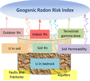
    The JRC has undertaken to map a variable which measures “what earth delivers” in terms of geogenic radon potential, due to heterogeneity of data sources across Europe and the need to develop models for estimating a harmonized quantity which adequately measures or classifies the radon potential. The European Geogenic Radon Map will give the possibility to characterize areas for radon risk where indoor radon measurements are not available. A multivariate classification approach to estimate the geogenic radon potential has been developed and was proposed to the scientific community. In this context, multivariate estimation means to use information from several quantities which are physically related to radon, to assess a radon quantity of interest. Some countries which have several input quantities available have already been testing this approach.

    It has been decided to give priority to the development of those maps that should be part of the European Atlas of Natural Radiation but also be used as input parameter in the European Geogenic Radon Map. For some countries the terrestrial gamma dose rate map has been created and maps of uranium concentration in soil and bedrock have been created.

    STAY TUNED, WE KEEP YOU UPDATED ON THE PROGRESS!

    References

    • V. Gruber, P. Bossew, M. De Cort, T. Tollefsen, 2013. The European map of the geogenic radon potential. Journal  of Radiological Protection, 33, 51–60.
    • V. Gruber, T. Tollefsen, P. Bossew, M. De Cort, 2013. The European indoor radon map and beyond. Carpathian Journal of Earth and Environmental Sciences, 8(2), 169–176.
    • T. Tollefsen, G. Cinelli, 2016. Moderated discussion: Progress on European Geogenic Radon Mapping. Moderated panel discussion during the 13th International Workshop on the Geological Aspects of Radon Risk Mapping, Prague 15-16 September 2016. Download
    • P. Bossew, G. Cinelli, T. Tollefsen, M. De Cort, 2016. Multivariate estimation of the geogenic radon potential and prediction of indoor Rn concentration. Oral presentation during the 13th International Workshop on the Geological Aspects of Radon Risk Mapping, Prague 15-16 September 2016. Download
    • D. Appleton, 2012. User Guide for the BGS-HPA OneGeology Radon Potential Dataset for the UK. British Geological Survey Open Report, OR/12/082. 18 pp. Download

    Additional Information

    Resolution:

    Last Modified: 25/10/2016

    Update frequency: Irregular